-
David Dorchies authoredDavid Dorchies authored

pente.md 1.18 KiB
Slope
Definition
The slope used in all Cassiopée's modules is the topographic slope:
The grade (also called slope, incline, gradient, mainfall, pitch or rise) of a physical feature, landform or constructed line refers to the tangent of the angle of that surface to the horizontal. (Source: Wikipedia)
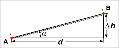
The slope ((I)) in m/m used in Cassiopee's modules is:
Important:
All calculation modules consider a descending slope as positive except for the "Jet Impact" module where a positive slope will be considered as rising and vice versa. To invert the slope in a calculation sequence of linked modules, use the "linear function" module with (a= -1) and (b=0).
The "Slope" module
This tools allows to calculate the missing value of the four quantities:
- upstream elevation ((Z_1)) in m;
- downstream elevation ((Z_2)) in m;
- length ((d)) in m;
- slope ((I)) in m/m, with (I = \frac{(Z_1 - Z_2)}{d}).